Go to section
About the Area Near Clio, CA, Middle Fork of the Feather River and Graeagle
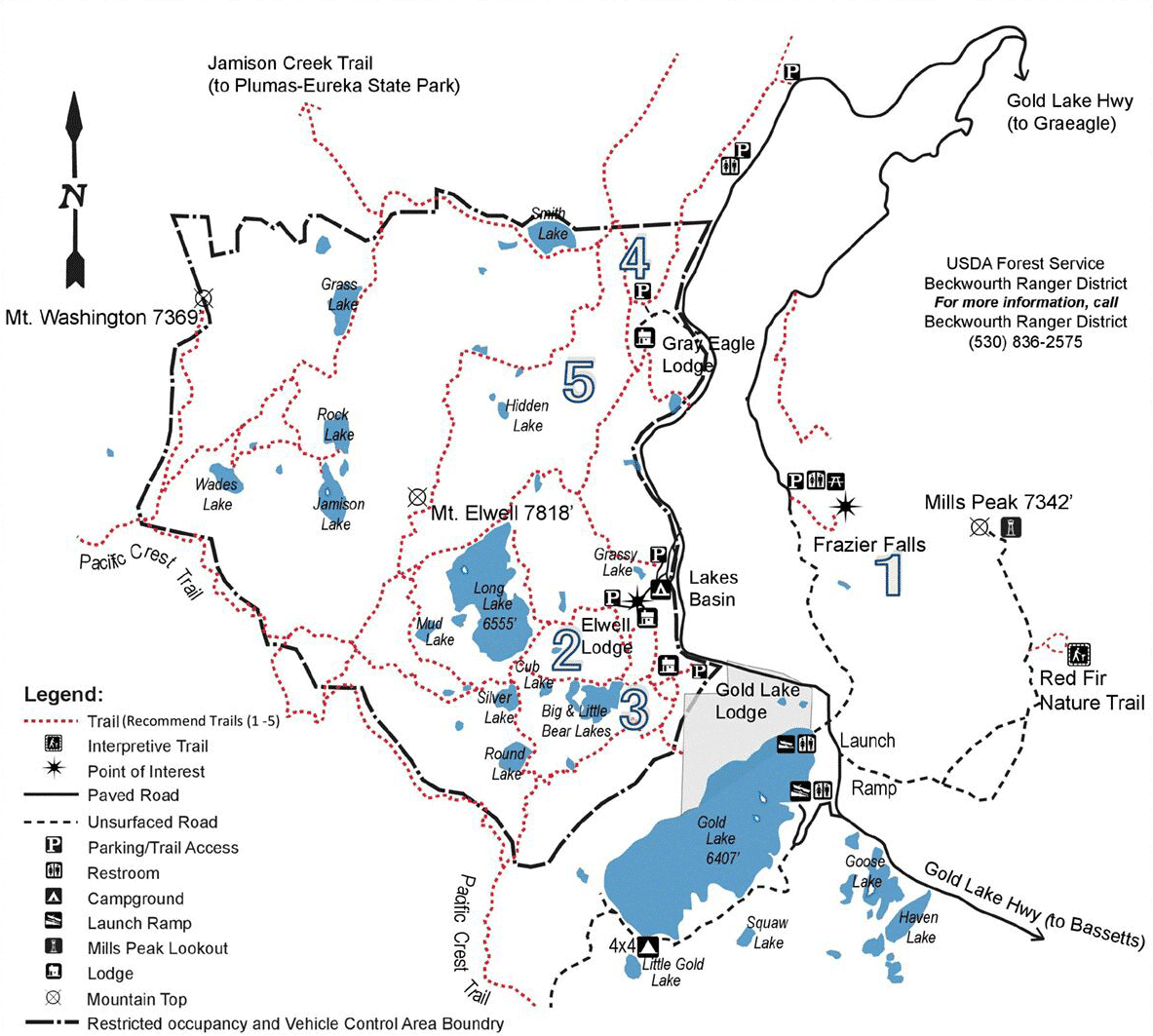
The Lakes Basin Recreation Area in the southeastern part of the county near Clio’s RV Park has hundreds of great hiking trails, including a loop trail that leads past nine mountain lakes.
Hikers can climb to the top of the Sierra Buttes, Mt. Elwell or Eureka Peak, while others may prefer a less strenuous hike to Madora Lake, located within Plumas Eureka State Park.
The Lake Davis Recreation Area, north of Portola has a 5.1 mile hiking trail along the east shore of the lake that accesses the campgrounds, and another four miles was added last year.
Dogs are welcome (leash preferred) on all National Forest hiking trails. Within Plumas-Eureka State Park, dogs are only allowed on the Grass Lake trail, and dogs are not allowed on hiking trails in Lassen Volcanic National Park, although they are welcome in the parking lots, roads and road shoulders, campgrounds and picnic areas.
Plumas County's 1,000 miles of streams and more than 100 lakes of the Feather River watershed make for a wonderful, varied and famous fishery. Whether you're a fly fisherman or prefer to use lures and bait, you'll find plenty of places to reel them in. Please visit the link below for specific regulations and limits.
| Lakes nearby: Gold Lake Silver Lake Lost Lake Sardine Lake Salmon Lake Lake Davis |
Stream and fly fishing in the area: Feather River / North Fork and Middle Fork Yellow Creek in Humbug Valley Jamison Creek near Graeagle Other: Indian and Wolf Creek, Nelson and Spanish Creek |
7 golf courses within 7 miles and a miniature golf course just down the road for the whole family. See links below for more information:
White Hawk A Dick Bailey designed course carved from the natural terrain of the MohawkValley.
The Dragon at Nakoma One of America’s Top 75 according to Golf World. Designed by Robin Nelson, who also designed the famous Dunes at Mauna Lani on the Big Island.
Graeagle Meadows “Golf Digest” includes Graeagle on its list of “Best Places to Play.”
Plumas Pines Voted 9th Top Golf Course in California—golfadvisor.com
Grizzly Ranch Golf Digest ranked this course the #1 public-accessible course in the Sierra Nevada.
Feather River Inn This stunning par three track stays true to its original design concept: a course that is enjoyable, well kept, and rewarding in play.
Feather River Park Resort A 9-hole course in the Mohawk Valley situated in the resort.
Graeagle Miniature Golf and Driving Range On Hwy. 89, 530-836-2107
Horseback Riding
Ride in the High Sierra! There are a number of stables and equestrian centers in Plumas County that offer trail rides, instruction for individuals and family with or without prior horseback riding experience. Some stables nearby:
Graeagle Meadows Highway 89 | Gold Lake Stables Gold Lake Road


Biking
Local Restaurants:*
Chalet View Lodge | 836-2511
Cuccia’s | 836-2121
Longboard's Bar and Grill | 836-1111
Nakoma Fifty44 Resort | 897-2300
Graeagle Meadows Clubhouse Restaurant | 836-2348
Graeagle Restaurant | 836-2393
Gray Eagle Lodge | 836-2511
Gold Lake Lodge | 836-2350
Grizzly Grill | 836-1300
Gumba’s | 836-1212
Sardine Lake Resort | 862-1196
The Iron Door | 836-2376
Local Cafes:
Graeagle Frostee | 836-4811
Beer & Wine Taverns:
The Brewing Lair | 394-0940
Knotty Pine Tavern | 836-2536
Mohawk Tavern | 836-1241
The Peak | 836-7325
*All (530) Area Code
Shopping in the Graeagle Area
Briar Patch, Gift Shop | 836-2588
Feathers Gifts and Accessories, Gift Shop | 836-1963
Graeagle Chevron | 836-2309
Graeagle Market, Groceries | 836-2519
Graeagle Medical Clinic | 836-1122
Graeagle Mercantile & Event Flowers, Gift Shop | 836-2515
Mountain Hardware | 836-2589
Queen Bee Boutique, Boutique Shop | 836-0322
Mountain Biking Resources
Single Tracks is a great resource for trail maps.
Other resources suggest these rides:
Eastern Plumas
Mills Peak Lookout
Distance: 6 miles (one-way)
Effort: Moderate
Average Ride Time: 1.5 hours
Lake Davis Loop
Distance: 18 miles
Effort: Easy
Average Ride Time: 2 hours
Dixie Mountain
Distance: 15.6 miles
Effort: Difficult
Average Ride Time: 2 hours
Crystal Peak
Distance: 10.5 (one-way)
Effort: Moderate
Average Ride Time: 2 hours
Central Plumas
Summit-Bucks Creek Loop
Distance: 3.8 miles
Effort: Easy
Average Ride Time: 1 hour
Howland Flat Loop
Distance: 19 miles
Effort: Difficult
Average Ride Time: 5 hours
Round Valley Lake Loop
Distance: 12 miles
Effort: Moderate
Average Ride Time: 2 hours
Antelope Lake Loop
Distance: 11 miles
Effort: Easy
Average Ride Time: 1.5 hours


